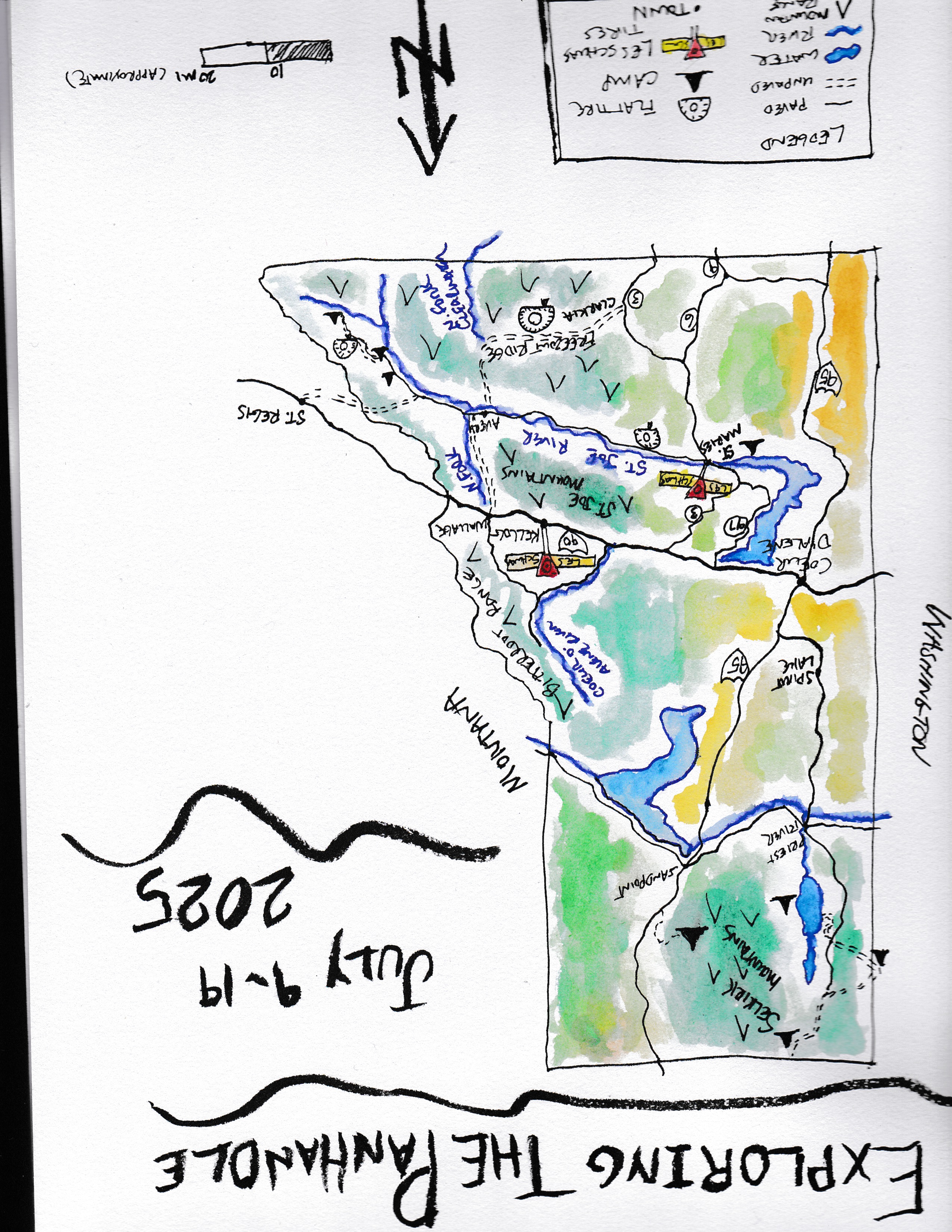
Driving around eastern Washington, I’ve always been a bit confused. Some of the landforms and supposed drainages just don’t make sense. It turns out there is a reason for that. Massive ice age floods shaped the region with forces and water at levels that are impossible to comprehend. I can only imagine the reaction when the geologist J. Harlan Bretz proposed that these features were shaped by a series of massive floods. The amount of water and the speed at which is flowed is just simply at a scale of nothing that has ever been observed. He put the pieces together and along with the discovery of the existence of prehistoric lake Missoula that existed during the past ice age, the geology community finally came to accept his theory as fact.
After a lot of our own research, and putting some pins in the map, we came up with a trip plan and set out to see the pieces of the Ice Age Flood puzzle for ourselves.

The Palouse
The trip started out like it sometimes does when we head west, with a drive through the Palouse. The Palouse is an area of rolling hills and very little else. The word scenic doesn’t necessarily come to mind as we drive across this area, other than the sign that says we are travelling on the Palouse Scenic Byway. It’s not as ugly as an urban area, but scenic is a bit of a stretch. The Palouse was the first piece of our puzzle for this trip though so it held a bit of significance.

The hills of the Palouse are formed of wind blown loess, a silty soil that turns out to be fertile ground for growing things, especially wheat. The Palouse loess hills used to cover a larger areas across eastern Washington, but some of that area was eroded away by the ice age floods and now consists of the “channeled scablands” that were the real target of our trip. So the Palouse gives us a clue to what this area looked like pre flood. Well, without all the wheat of course. There was also an intact ecosystem here that is now all but eliminated.
Palouse Falls
Our first stop was Palouse Falls. Washington’s state waterfall is pretty impressive, plunging off a cliff to a pool 200 feet below. But what makes it really impressive is the canyon of basalt it sits in. 17-14 million years ago the Columbia River basalt flows covered an 80,000 square mile region of Idaho, Washington and Oregon with basalt that is in some places 2.5 miles thick. While the Palouse loess hills cover up these basalt flows with 150 feet of silt, where the ice age flood washed over the land, they eroded that silt away to reveal these amazing layers of basalt. Palouse falls is but a tiny remnant of flows that originally formed this impressive landscape.

After our tour of the falls we headed to the nearby lower Snake river and settled in for the night. The Army Corps of Engineers has several camping areas along the river, and we found one we had all to ourselves. Even before sunset an owl began to hoot. A pheasant was crowing, and later the coyotes started their serenades from the cliffs. It sure felt good to be out and about again as we left winter in the rear view mirror.


Wallula Gap
After a night of owls and coyotes we headed to find our next piece of the ice age floods puzzle we were collecting. Wallula gap is located near the Oregon Washington Border on the Columbia River. During the ice age floods, water was constricted through this mile wide gap, and backed up as far as Walla Walla and Yakima forming a transient lake, Lake Lewis, stretching over 100 miles long and 130 miles wide. Sediments have been discovered that indicate that there may have been nearly 100 such floods occurring over several years as ice dams that held back historic lake Missoula broke and released the flood waters.

Evidence of the amazing amount of floodwaters that flowed through this area includes the twin sisters, twin basalt outcrops overlooking the gap.

Looking upstream on the Columbia it is difficult to imagine everything in sight being inundated by water, and flows that reached 60 miles per hour rushing by.


We headed up the Columbia and stopped for a hike at the White Bluffs, located at the Hanford Reach National Monument. There is more evidence of Lake Lewis you can observe here. Layers of white sediment as well as granite boulders of all sizes settled out as the lake formed after being carried many miles by the floods. The granite is odd to see here, carried in the floodwater from Montana and Idaho, since the native landforms are all the basalts that cap the entire area. They were another piece of that puzzle that was starting to come together.

Ginkgo Petrified Forest
The next day we made our way to the Ginkgo Petrified Forest State Park. The logs that are petrified here have their own story to tell of a time well before the floods. Ginkgo, redwood, elm, maple, walnut, spruce are remnants of a forest that existed here 23 to 5 million years ago during the Miocene epoc. So what do trees that existed that long ago have to do with the relative recent ice age floods that occurred merely 21,000 to 16,000 years ago? Well, the petrified logs were exposed by the erosive power of the floods, if it weren’t by the floods, the logs would still be buried under the Columbia River basalt flows.

The state park features a trail to several specimens that are still in their original location, but unearthed to expose them for observastion.


Frenchman and Potholes Coulees
Coulees seem to be a common feature across eastern Washington. Why? You guessed it, the ice age floods. But what exactly is a coulee anyway? A coulee is a steep walled trench formed by floodwaters. As opposed to a canyon that may typically be in the shape of a V having formed by smaller flows over a long period of time, a coulee has straighter walls that may look more like a trench. Frenchman Coulee was the first coulee on our tour of the ice age floods. To imagine the amount of water that formed this now dry coulee is nearly impossible.


We didn’t stay long at the Frenchman Coulee because we had another Coulee to see, the Potholes Coulee.

We drove around the Quincy Wildlife Area long enough to find a camp before setting off to hike the coulee.

We hiked down into the coulee to Dusty Lake. The potholes gets its name for all the pothole lakes that fill the coulee with water from the Columbia Basin project.

After our hike we sat on the rim and watched the sun set, still trying to comprehend the scope of these floods.

Even though the scope is hard to grasp, we now had some understanding of the formation of coulees. With another piece of the puzzle picked up, we were off in the morning to another location of yet another piece.
Drumheller Channels and the Columbia National Wildlife Refuge
From a distance the Drumheller Channels don’t look like much. A confused pattern of drainages and basalt mesas carry a couple small streams and are dotted by a few pothole lakes. When the ice age floods passed through here they didn’t flow through one path but formed several weaving channels that left behind a complex landscape of scabland we see today.

As we walked up one of the channels on a closed road turned hiking trail, we ended up surprising a coyote that was more intent on the bird he had in his sights than us. Once he glanced our way he quickly headed for the ridgeline and another one of the channels to continue his hunt for breakfast.

While here we also visited the Pipistrelle Cliffs, which are composed of columnar basalt. These large hexagonal columns are formed as the lava flow cools and shrinks forming the hexagon shapes of the columns. The cliffs were of course exposed due to the erosion of the ice age floods.

The interesting thing about these particular cliffs is that you can hike to the top of them and see how deep they actually run into the hillside. There are many more columns with their tops exposed, revealing that the entire mesa is composed of columns.


We continued north through the refuge and found a spot where migrating sandhill cranes were on a stopover on their long trip north for the summer. There were thousands of birds taking a rest on their long journey. They were off in the distance with us humans kept away to minimize disturbance to what I am sure is an already taxing journey.

Once we settled in to camp along the shore of Potholes Reservoir we were treated to several flyovers of cranes as well.


As the sun set we actually had a view of the summit of Mt. Rainer. We were treated to the best sunset of the trip as well.


The cranes just kept coming. Thousands of them. If you haven’t witnessed the migration of sandhill cranes, get yourself to central Washington next spring.

As the cranes continued north, we set our sights in that direction as well. Our quest for more pieces of the puzzle of the ice age floods continues in part 2.

Wonderful TR, Ed! Thanks for letting us tag along!
Beautiful photos Ed.
Appreciate the trip report. Well done. I learned a lot about the eastern part of my state..
I am so glad to have come across your wonderful video and website. I live in Arizona and am planning a July and August trip to follow the Ice Age Floods National Geologic Trail. Thank you so much.
Question: did you ever use 4-WD? I don’t have 4-wheel drive.
You should be fine without 4WD. We didnt need it. All the off pavement roads we traveled were gravel roads for this trip. Glad you found us andnhave a great trip! We of course stuck to Washington on this trip but the Trail is much more extensive.